RHODE ISLAND LIGHTHOUSE AND NEWPORT HARBOR TOUR
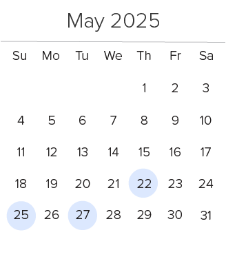
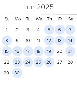
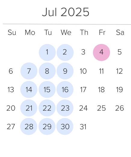
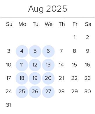
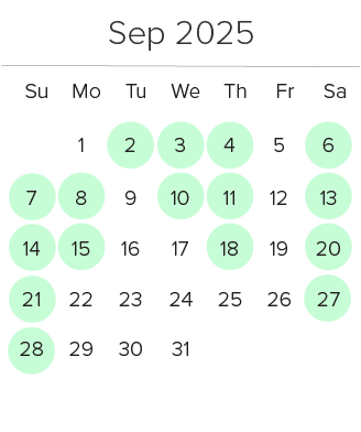
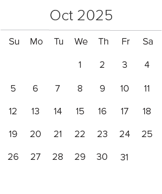
2025 Lighthouse Cruise Schedule & Rates
| Depart Quonset | Return |
|---|---|
| 2:00 PM | 3:40 PM |
| Depart Quonset | Return |
|---|---|
| 1:00 PM | 2:40 PM |
| FIREWORKS CRUISE - More Info | Return |
|---|---|
| 7:30 PM | 9:45 PM |
* Sailing Schedules are subject to changes without notice, all trips are 100 minutes in duration and may vary in length due to tide and weather conditions. We recommend that passengers arrive at least 45-minutes prior to departure in Quonset Point. Reserved tickets that are not redeemed by boarding 15-minutes prior to departure will be released to standby passengers.
2025 Lighthouse Cruise Rates
| Passenger Rates | Advance Reservation | Walk in Purchase |
|---|---|---|
| Adult (12-59) | $39.00 | $44.00 |
| Senior (60 yrs. and older) | $37.00 | $42.00 |
| Children (3-11) | $25.00 | $30.00 |
| Infants (0-2) | FREE with Reservation | $5.00 |
| Fireworks Cruise - Special Rates Apply - More Info --> | ||
*Advanced Reservation Rates*
*Advance Online Reservations are highly recommended and are discounted by $5.00 per ticket. Reservations can be made conveniently online or over the telephone. Children under 2 ride free with an advance reservation. The above rates are subject to change without notice.
Fare Rules & Ticket Redemption Policies
- ALL TICKETS ARE NON-REFUNDABLE: Unless purchased with Assurance, all tickets are non-refundable.
- MODIFYING YOUR TRIP: Modifications to your reservation must be made 24 hours prior to departure. If purchased without Assurance, a $3.00 per person Modification Fee along with any fare difference will apply.
- NO SHOW POLICY: If you fail to make your scheduled departure, your ticket will no longer be valid, and therefore you will be required to make a new reservation. You must contact us 24 hours prior to missing your scheduled trip to avoid ticket forfeiture.
- STAND-BY POLICY: If a departure is sold out, we will try to accommodate passengers that wish to stand-by for boarding. Stand-by passengers are boarded on a first-come, first serve basis from the standby line. Unclaimed reservations are released 3-5 minutes prior to departure after all ticketed passengers have been boarded. All Standby customers will be required to purchase tickets for the trip they are boarding.
**Security Notice** All passengers, personal items may be subject to search and inspection prior to boarding our vessel and/or anytime while on board the vessel under the Maritime Transportation Security Act of 2002. We ask that travelers plan accordingly for the possibility of these pre-boarding requirements. Passengers who refuse to submit to a search will be denied boarding.
RHODE ISLAND LIGHTHOUSE TOUR MAP
The cruise is 30 miles in length and passes by some of the most beautiful coastline in Rhode Island with breathtaking waterfront scenery. Below is the actual tour route you will take past the Lighthouses as well as many other scenic sights through Narragansett Bay. The Map below is interactive; you can zoom in and out, change from Terrain to Satellite or to a traditional Map, as well as grab and move the map with your mouse. You can also click on the red and yellow pins for more information.
10 RHODE ISLAND LIGHTHOUSES OF NARRAGANSETT BAY
This 90-minute cruise showcases some of Rhode Island’s most beautiful Lighthouses. Our captain will take you throughout Narragansett Bay bringing you up close and personal to these historic landmarks; this truly is a one-of-a-kind cruise that you will remember forever. Below are the Rhode Island Lighthouses you will see along the way as well as their factual information, don’t forget to bring your camera and binoculars!
Poplar Point Lighthouse
Location: Wickford, Rhode Island
Accessibility: This lighthouse is not open to the public
Established: 1831; Present lighthouse built: 1831; Discontinued: 1882
Construction material: Wood
Height of focal plane: 48 feet
Lighthouse is privately owned.
Plum Beach Lighthouse
Accessibility: Not open to the public, best viewed by boat.
Station established: 1899; Present lighthouse built: 1899
Construction material: Cast iron
Height of tower: 53 feet; Height of focal plane: 54 feet
Lighthouse is owned by: Friends of Plum Beach Lighthouse. Active Navigational Aid.
Dutch Island Lighthouse
Accessibility: The lighthouse is not open to the public and is best seen by boat.
Station established: 1826; Lighthouse built: 1857; Discontinued: 1979
Construction material: Brick
Height of tower: 42 feet; Height of focal plane: 56 feet
Characteristics: Red light; two seconds on and four seconds off.
Whale Rock Lighthouse
Location: The entrance of the West Passage of Narragansett Bay
Nearest town: Narragansett, Rhode Island
Station established: 1882; Destroyed: 1938 Hurricane
Beavertail Lighthouse
Accessibility: Grounds in Jamestown are open to the public; museum in the keeper’s house. The tower is not open to the public.
Station established: 1749; Present lighthouse built: 1856
Construction material: Granite
Height of tower: 53 feet; Height of focal plane: 54 feet
Characteristics: Flashing white every six seconds. Active Navigational Aid.
Castle Hill Lighthouse
Accessibility: The lighthouse is not open but the grounds are adjacent to the Castle Hill Inn and are open to the public.
Station Established: 1890; Present lighthouse built: 1890.
Construction Material: Granite
Height of Tower: 34 feet
Characteristics: Six seconds red alternating with six seconds darkness. Active navigational aid.
Lime Rock Lighthouse (Ida Lewis YC)
Accessibility: The yacht club is not open to the general public on a regular basis. Best views are from the harbor.
Station Established: 1854; Discontinued: 1927 (relighted later as a private aid)
Construction Material: Stone Height of tower: 13 feet; Height of focal plane: 30 feet
Present Optic: Lantern in original tower, lit May to October.
Newport Harbor Lighthouse (Goat Island)
Accessibility: The yacht club is not open to the general public on a regular basis. Best views are from the harbor.
Station Established: 1823; Present lighthouse built: 1842.
Construction Material: Granite
Height of Tower: 35 feet
Characteristic: Fixed green
Active Navigational Aid.
Rose Island Lighthouse
Accessibility: Rose Island is accessible by ferry from Newport or Jamestown.
Station Established: 1870; Deactivated: 1971 – 1992, Re-Lit 1993
Construction Material: Wood with masonry foundation
Height of Tower: 35 feet; Height of focal plane: 48 feet
Characteristics: Flashing white every six seconds
Private aid to navigation/guest house.
Conanicut Lighthouse
Accessibility: This lighthouse is not open to the public and is best viewed by boat.
Station established: 1886; Discontinued: 1933
Construction material: Wood
Present optic: None
Characteristics: Flashing white every six seconds
Lighthouse is privately owned.
OTHER SIGHTS YOU WILL SEE IN NARRAGANSETT BAY
Jamestown-Verrazano Bridge
Sailing under the Jamestown Bridge which spans the West Passage of Narragansett Bay and links the towns of North Kingstown and the Island of Jamestown. The Jamestown-Verrazano Bridge was built in 1992 and is 8,500 feet long and is 674 feet high above the center navigational channel.
Castle Hill, Newport
Situated on a forty-acre peninsula, at the west end of Newport’s world renowned Ocean Drive, Castle Hill Inn & Resort is an extraordinary beauty of a private oceanfront resort.
www.castlehillin.com
Hammersmith Farm, Newport
A Victorian mansion with 28-rooms and surrounding property located in and was the childhood home to Jacqueline Kennedy Onassis. The property hosted the wedding reception of Jacqueline and John F. Kennedy. During his presidency, Kennedy spent enough time at Hammersmith Farm that it was referred to as the “Summer White House.” The house was recently sold to the owner of Fruit of the Loom and is no longer open to the public.
Ocean Cliff, Newport
Located on 10 acres of rolling lawns with spectacular ocean views, the Ocean Cliff offers a truly unique blend of breathtaking beauty. Ocean Cliff has twenty-five guest rooms that whisk you back to the 19th century with modern conveniences, stunning oceanfront views and world-class cuisine.
www.newportexperience.com
Clingstone “House on the Rock”, Jamestown
Clingstone, a 1905 shingled residence built on a rock outcropping in Narragansett Bay off Jamestown, is a truly unique home. It has 6 bedrooms, 5 bathrooms and offers unparalleled views from every room. This island home can only be accessed only by boat and has its own generator. The house can actually be rented for $7,500 per week during the summer months.
House on the Rock – NY Times Article
Fort Adams, Newport
Fort Adams is the second largest masonry fortification in the United States, exceeded only by Fort Monroe in Virginia. The site was first fortified with an earthwork battery in 1776 during the American Revolution; the guns were instrumental in driving British warships from Narragansett Bay in May of 1776. Named after then President John Adams the fort was designed to mount 464 cannon and be garrisoned by 2,440 soldiers in wartime. In 1985 Fort Adams was designated a National Historic Landmark – and is now a public State Park.
www.fortadams.org
Newport Harbor
Cruise through famous Newport Harbor; you will get an up close and personal tour of the second largest sailing port on the East Coast while viewing the historic architecture along the shoreline.
Sailboats & Yachts
View classic wooden sailboats to 12 meter class sailing vessels as well as multimillion dollar yachts along the Newport Harbor waterfront.
Commercial Ships
Rhode Island accommodates all types of commercial vessels in its waterways; as you cruise throughout Narragansett Bay you may see Cruise Ships, Oil Tankers, Tug Boats, Coal Barges, Yacht Transport Ships and Fishing Vessels.
Newport Pell Bridge
Sailing under the Newport Bridge which spans the East Passage of Narragansett Bay and connects the town of Jamestown on Conanicut Island and the City of Newport on Aquidneck Island. The Newport Pell Bridge was built in 1969 and is 11,250 feet long and is 215 feet high above the center navigational channel. This is the largest Suspension Bridge in all of New England.
Knowledgeable, Entertaining Tour Guides
The tour is narrated by one of our pair of knowledgeable, entertaining guides, Matthew Ulrickson and Brian Wallin. Their historical facts and folklore will entertain and educate you and your guests.
DIRECTIONS & PARKING
Our departure location in Quonset Point, North Kingstown is convenient and easy to reach from anywhere in Rhode Island, whether you are in South County, Warwick, Providence or Newport we are just a short drive away. We also offer free dockside parking for all of our Bay Cruises.
Approximate drive times to Quonset Point from – Providence (25 minutes), Warwick (15 min), Newport (30 min), Jamestown (15 min), Narragansett & South Kingstown (20min), Charlestown (30 min), Westerly (45 min), Mystic CT (1 hr.)
Dockside Parking – Complimentary for Cruise Patrons
We have an enormous dockside parking lot here in Quonset Point – our ticket office, parking lot, and the the ferry dock are all part of the same facility. It’s that easy, navigate to 1347 Roger Williams Way, North Kingstown, RI, pay to park, park your car a few hundred feet from the dock, and you’re ready to enjoy your trip!
Directions from the Narragansett, South Kingstown and Westerly area:
Take Rt. 1 North. After passing the Newport/Jamestown Bridge Exit continue driving on Route 1 North for 7.5 miles to Exit 7 (Quonset). Take Route 403 for 3 miles and then stay Left following the signs to Quonset. Continue on Route 403/Quonset Rd. for 3.5 miles to the water, we are on the right-hand side. Look for the Martha’s Vineyard Ferry signs.
Directions from the Massachusetts and Providence area:
Take I-95 South to Exit 9 (Route 4 South). Continue on Route 4 South for 2 miles and take Exit 7B (Quonset Point / Route 403). Take Route 403 for 3 miles and then stay Left following the signs to Quonset. Continue driving on Route 403 / Quonset Rd. for 3.5 miles to the water, we are on the right-hand side. Look for the Martha’s Vineyard Ferry signs.
Directions from Jamestown and Newport area:
Drive over the Newport and Jamestown Bridges . After going over the Jamestown Bridge continue driving for 2 miles and take the Route 1 North Exit ( Providence ). After merging onto Route 1 North continue driving for 7.5 miles to Exit 7 (Quonset). Take Route 403 for 3 miles and then stay Left following the signs to Quonset. Continue driving on Route 403/Quonset Rd. for 3.5 miles to the water, we are on the right-hand side. Look for the Martha’s Vineyard Ferry signs.
Private Charters and Groups
Group Rates are available for 15 or more passengers, advance reservations are required. Group rates are subject to availability. Please call our office at 401-295-4040 and ask for a Group Manager.
Our vessels are available for private charters for private tours and events. Please call our office at 401-295-4040 and request to speak with a Group Manager.

